fbpx
Article

Truth From The Stand Podcast #23: Hunting Buck Beds & East Coast Public Land W/The Bowhunting Fiend

Today on the show I’m joined by Greg Litzinger, also known as the Bowhunting Fiend. Greg is a hardcore public land hunter who predominantly hunts the high pressure state of New Jersey. An avid self filmer, Greg recently joined the Behind The Bow crew who share Greg’s passion for whitetail, and his DIY approach. I’m looking forward to seeing the footage he captures from his public land hunts this coming year. Whether Greg is scouting salt marshes in the off season, finding buck beds, or shooting 3D, one thing is for sure—he lives, eats and breaths bowhunting!

To listen to the podcast click the orange play button at the top of the page.  You can also download the podcast via iTunes, Stitcher Radio and Google Play—don’t forget to  share with your friends! If you like the podcast, please leave us a 5 star iTunes rating…we’d really appreciate it.

Click here to listen/subscribe on iTunes (best for iOS devices)

Click here to listen/subscribe on Stitcher (best for Android devices)

Click here to listen/subscribe on Google Play Music (another option for Android devices)

What To Expect From Podcast #23:

—Greg’s background

—Greg’s 2016 season

—Number of properties he scouts in a year

—Favorite time of year to scout

—Scouting and hunting buck beds

—Hunting and scouting hill country

—Hunting and scouting swamps

—Moon phase fact or fiction

—Woodsman ship vs. technology

—Self filming and joining Behind The Bow

—Prepping for an elk hunt

—Greg’s gear

—Greg takes us on a hunt

Show Notes And Links:

—Visit our partners  Exodus Outdoor Gear , Whitetail Institute of North America, and Lone Wolf Portable Treestands

—Be sure to follow Greg  Instagram and Youtube

—Check out Buck Bumper from Sound Barrier and take your stealth to the next level. Use the promo code “the stand” and get 10% off at check out!

Article

Deer Scouting PA Public Land Video: Part 2

Two weeks ago I took to the timber  to scout a new piece of public ground and documented my scout in a 2-part video series. The scout hit a bit of a lull in the middle of the day with the area I was holding high hopes for leaving me a little disappointed. That said, the day ended on a high note and holds promise for next year!

Below is video 2 of this series, and you can view part 1 of the series here—enjoy!

Article

Deer Scouting PA Public Land Video: Part 1

Hey gang, If you’re like me you’ve been itching to get back into the timber and get your 2017 hunting season started. This past weekend’s phenomenal weather (and a 3 day weekend) gave me an opportunity to hit some public land that I had been planning to scout. I did manage to fit in a little shed hunting, but since I’m possibly the world’s worst shed hunter I decided to make a deposit in the 2017 big buck bank account with some scouting.

In this 2 part video series I”ll bring you all with me on a full day of public land scouting on a parcel I’ve only viewed from aerial maps prior to these videos. The total parcel is 1,700 acres, but I’ll  be focusing on only a few hundred.  These videos are meant to be DIY/no frills. Just scouting and putting in miles. Hope you enjoy the video, and part 2 will be coming soon.

Could YouTube find a more ridiculous shot of my face to use as a thumbnail?

Article

Truth From The Stand Podcast #16: Mature Buck Bedding & High-Pressure Public Land Hunting w/ Dan Infalt

Today on the show Phil and I are joined by Big Buck Serial Kill, Dan Infalt. Dan Likely needs no introduction to many of you, as he’s well known and highly regarded throughout the whitetail community as a hunter whose tips and strategies have helped many take great deer. Dan’s approach to hunting high-pressure public lands and mature buck bedding has allowed him to regularly take the top bucks in the areas he’s hunting. On today’s show, Dan will share this approach to hunting high-pressured public lands and how to locate mature buck bedding and more!

To listen to the podcast click the orange play button at the top of the page.  You can also download the podcast via iTunes, Stitcher Radio and Google Play—don’t forget to  share with your friends! If you like the podcast, please leave us a 5 star iTunes rating…we’d really appreciate it.

Click here to listen/subscribe on iTunes (best for iOS devices)

Click here to listen/subscribe on Stitcher (best for Android devices)

Click here to listen/subscribe on Google Play Music (another option for Android devices)

What To Expect From Podcast #16:

—Dan’s background

—Hunter’s growing affinity for hunting public lands

—Qualifying a piece of land prior to hunting (hill country and swamp land)

—Hunting areas close to access points

—Best time to scout is during the season

—How to use/hunt the sign you find

—Locating buck bedding

—Terrain features and buck bedding

—Using buck bedding to see what the buck sees

—What is a bucks “save zone” and how to hunt near it

—Defining primary bedding vs. seasonal bedding

—Dan’s 3 stands theory

—Rut Bedding

—How bucks use the wind to enter and exit bedding

—How to hunt off wind and thermals

—Dan’s approach to using the moon

—Dan’s approach to observation sits vs. kill sits

—How Dan uses game cameras

—Dan’s stalking story of his 180 inch Wisconsin swamp buck

Show Notes And Links:

—Check out Dan’s website and forum, The Hunting Beast

—Be sure to check out  The Hunting Beast videos on YouTube 

—Follow The Hunting Beast on all their social media platforms: ( Facebook and Twitter )

—Visit our partners  Exodus Outdoor Gear , Whitetail Institute of North America, and Lone Wolf Portable Treestands

Article

Planning An Out Of State Public Land Hunt: Ohio 2016

Last year I considered heading to Ohio for a late fall DIY public land archery hunt. I’ve never hunted Ohio and was planning to tag along with a few friends who make a trip to the Buckeye state regularly. Unfortunately, our plans fell through, so this season I decided I’d make plans to go solo if need be.

Hunting a new state can be a challenge, and visiting new state to hunt public land has the potential for disaster. There are oftentimes more questions than answers. What part of the state has good hunting? How much public land is available to hunt? How much hunting pressure do public lands get in Ohio? Despite the challenges, I was determined to complete this public land hunt in 2016.

Location, Location, Location

When I began planning, the only thing I knew was that I’d be hunting public land in Ohio. I chose Ohio since it’s the closest big buck state to me, geographically, and out-of-state tags can be purchased online at a reasonable cost. My next step was to figure out in what county I’d be hunting. After I did a little online research, I quickly realized that Ohio has more public land than I had anticipated.

I determined I’d like to hunt in the southern region (a known big buck county) of the state and was intrigued by the AEP land. AEP land is land once strip-mined for coal in the 1940’s and eventually purchased by AEP. Since then, a vast reclamation project, to the tune of 60,000 plus acres across the state, has created ideal habitat for a variety of wildlife.

The Ohio DNR and AEP website were great resources for my initial map and habitat research.  I was able to view maps for various locations and read descriptions of the habitat and type of wildlife the specific sections of public land is best suited to support. Some lands were focused on providing grasslands for bird hunting and smaller game, while other sections centered on more big timber and row crops for larger game.

With the county determined and a few larger tracts of public land selected, it was time to begin zeroing in on land features, topography and working toward identifying specific hunting locations. I first used a standard boundary map on the AEP website to identify what was public land vs. private land and to eliminate areas that may be used by hikers, bikers, campers etc… I wanted to get as far away from human activity as possible. After surveying the boundary maps I decided to focus on an area of river bottom to the north with steep ridges to the south.

Online Scouting

Since I live a little more that 7 hours away from where I’d be hunting, doing a drive by scout of the area wasn’t an option. My only option was to do my initial scouting online to uncover potential hunting locations. This helped me narrow my focus of land features I’d like to scout and be more efficient once I got to Ohio. One of my favorite scouting tools to use (regardless of my familiarity with a piece of land) is Google Earth. This is my go-to resource any time I’m reviewing new possible hunting lands.

While reviewing aerial images, I was looking for land and habitat features that may attract and hold deer. Ideally, areas that would be difficult to access, more than half mile from the access point, found their way to the top of my list. I also looked for areas with a reduced likelihood of running into other hunters, elevation changes with varying terrain features (saddles, pinch points, and drainage cuts), a food source if possible, and adequate cover. After several hours of scouting using Google Earth, I found a handful of locations that peaked my interest.

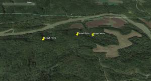
The area I was most interested in was a river bottom with two larger cornfields separated by a small strip of timber and a deep drainage cut running through. On the opposite side of the corn fields is a sharp elevation change, with what looked like a bowl feature at the top of the ridge. From what I could tell online, this area looked like it met all of my search criteria. I dropped a few pins on Google Earth and logged the GPS coordinates. Now it was time to put boots on the ground to confirm my online scouting assumptions.

Satellite image of the area I scouted. The pin to the far left will be the area I focus on this November

Ohio Public Land

Boots On The Ground

With my GPS coordinates logged, I set a date for a scouting trip to the Buckeye state. During the course of planning, my friend Tate and his buddy Eric decided to join me this fall and both were game for a late summer scouting trip. Two weeks before our scouting trip we had a meeting to iron out the details of where we were headed and the areas we’d be scouting. We met at Eric’s house and enjoyed a frosty pilsner as Eric gathered his folders containing the maps he’s used on his previous hunts in Ohio. I wasn’t sure where Eric had hunted in the past and was willing to change my hunting locations, even if he preferred a different county than I had scouted on line. After all, he’s been hunting Ohio Public land for years and would have a sense of where the better hunting would be.

We finished our beers and and Eric began pulling maps from his folder. At this point Eric has memorized land features, crop rotations cycles and perennial rub lines.  After sharing a few maps and thoughts, I asked what location he’d prefer to hunt.  As luck would have it, for 7 years Eric had been hunting the land I wanted to scout—it’s like we were meant to take this trip together. Having Eric on the trip would certainly cut down on some of the guess work.

4 a.m. came early on September 10th. I met the guys and we piled into my truck and headed west on the PA Turnpike, arriving at our destination around 8 a.m.  The food sources in this area were vast. Acres upon acres of corn and soybeans grew in every direction. There was no evidence here of the drought that we were experiencing across the state line. The timber was made up of a variety of hard wood with thick undergrowth—ideal whitetail habitat. The ridges were steep and the amount of green briar and brush made navigating the terrain difficult. The Google Earth images were as accurate as I’d hoped for.

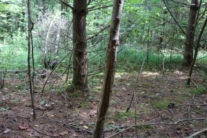
We scouted a few locations where Eric had hung a few stand in previous years before heading to the area that I was hoping would be my go-to spot. Once I got into the timber, I immediately noticed a handful of nice rubs at the base of the ridge. I began working my way up the ridge and came across several deer trails, with a well worn deer trail running diagonally up the ridge.

Rub from last year at the base of the ridge. This rub line runs the length of the ridge bottom.

Scouting Ohio Public Land

The entire ridge was thick and nasty with green briar. Once I made it to the top of the ridge, there was a small clearing in the brush with a tree that seemed well suited for a climber.  I also noticed this tree sat at the head of a drainage cut and on an edge where the brush gets almost impassably thick. The trails running the side of the mountain all led to this thick cover. It was clear deer were using the low lying feature of the drainage cut as an additional travel route and working the edge of the habitat change of the ridge top. This would be the location I’d focus on this November.

While scouting online I noticed the back side of this ridge had small depression between this ridge and the ridge just to the south. In general, I like terrain changes like this and in this steep country it seemed like a low lying area deer may use as an easier path to travel the ridge top.  I hiked out along the ridge top and dropped down the south side and into a bowl. There was buck sign everywhere along with some more well worn trails. This is one of those spots you get a feeling about. Something tells me this would be a great location and I’m pumped to spend some time hunting this area next month.

Final Thought

With my trip only a few weeks away, I feel confident about the locations I pinpointed in Ohio. My drive-by scouts consisted of pinch points leading into a food source  that I could clearly see on Google Earth and identify by driving past the location. The drive-by also confirmed what I assumed from my online scouting and the plan is to mix in these locations during my hunting trip. I’ll plan to hunt Ohio a few days during the first and second week of November, a few days in late November, and again in late season.

I’ve been looking forward to this trip for a year and am trying to keep my expectations reasonable. The possibilities and the unknowns of this trip, however intrigue me. Regardless of the outcome, the preparation, anticipation, and time spent with fellow hunters will keep me coming back for more.

Article

Deer Hunting & Scouting: Public Land

If you’ve read my previous articles, you’ve heard me mention our family farm and hunting property. It’s 240 acres of what I consider to be pretty fantastic Pennsylvania whitetail land and with the recent management approach we’ve taken, we should have even better hunting in the years to come. You can read more here (Whitetail Preseason Preparation: Setting Expectation) about our property management.  Although I certainly feel fortunate to have access to this land, our farm resides in the south central portion of the state near the Maryland border and is a three hour drive from my home in the suburbs of Philadelphia. This travel time significantly limits my hunting opportunities during archery season to a few Saturdays and a week’s vacation during the first week of November. This summer I decided that I’d try to find public land nearer my home to hunt when traveling isn’t an option. Another source of motivation was the early season opening in this part of the state and the opportunity to get into the timber sooner. I had little time and no prior experience with any of the land in the eastern part of the state. I had a lot of work to do and still not sure what my efforts may produce, but I was up for the challenge!

 My Approach

With limited knowledge of the area, I did a quick internet search for huntable state parks and  forests near me. I was willing to travel up to an hour for adequate hunting land and was looking for a piece of land, ideally, to the west, as I wanted to get further away from urban areas in hopes of reducing my run-ins with other hunters in the timber. I eventually settled on French Creek State Park as my destination.

 With my destination determined, it was time to assess the land for a suitable stand location. The park is over 7,500 acres with approximately half of it designated as huntable land. It would be impossible for me to scout over 3,000 acres in the one afternoon I had to find a stand location. So I made a plan and began with a virtual scout to focus my efforts once on site. Google Maps proved to be a great tool for this. Using Google’s satellite image, I could see the park layout and the neighboring land. I was looking for anything located remotely close to agriculture, but this feature was not an option. I then turned my attention toward the handful of what appeared to be thick brushy areas and decided this would be the area where I’d focus. With this small amount of information filed away, I made the hour drive to the park and paid a visit to the park office to grab a topography map. While sitting in my car, I did a quick review of the map and quickly ignored all areas with designated park hiking trails as huntable areas, with the goal of reducing the impact of human pressure. I then looked for topographic features, changes in elevation, pinch points, or creek bottoms. The northern portion of the park seemed the most remote and offered some elevation change with deep ravines and steep ridges and also included a stream. This would ultimately be the general area where I’d focus my scout.

 Once inside the timber, I knew I needed to hike in further than most people would be willing to with a stand and gear on their back to give myself the best chance of seeing natural deer movement. My goal was to hike a mile into the timber, knowing most public land hunters don’t typically travel much further than a half mile from their vehicle and entrance site. I looked for sign along the way and it was limited. After about 30 minutes, I began seeing sign that showed more promise–deer trails, scat and a significant amount of brush. I could hear a stream and started working my way toward the sound. The sound lead me through thick brush and to the edge of a deep ravine with the ridge lined in alder thicket. I found deer trails and bedding areas in the alder thicket and once I hiked down the ravine, there was a noticeable deer trail hugging the ridge line with the creek bottom supplying plenty of oak trees dropping acorns. I picked out a few climbable trees and had found my spot. This area provided plenty of cover, water, a food source, a topography change, clear bedding area, a natural pinch point between the ridge and the creek, and was relatively deep in the timber. In total, I spent two hours with boots on the ground scouting. Next was to hunt the location and see if my strategy and approach would pay off.

 The Test

Pennsylvania opening day had arrived. I was excited to get in my stand to say the least. Based on a few new strategies I’d implemented for this year, I previously decided to hunt only the evening set. The new (new to me) strategies were to hunt fewer mornings in October, unless camera, intel, etc.. tells me otherwise, and to use the Moon Phase Guide for the first time. According to the guide, I had a red moon for that evening beginning at 5:30 EST. I had thought if I was going to get any action out of this location, it would likely come from the thicket directly to my south. And for that to work I really needed any type of south wind. I arrived that afternoon, packed in my climber and gear, and climbed a tree about 50 yards below the pinch point between the ridge and the stream with the south wind I was hoping for. I honestly didn’t care if I saw a single deer, archery season was here and I was stoked just to be in the timber. A few  hours had passed with only seeing a hawk and one chipmunk. The moon time had arrived and I was hoping things would pick up. At 6 o’clock I heard some movement and spotted a deer coming from the thicket to the south. It was headed toward the ridge line just out of range. Two more deer followed the same path, all bucks–two 6-points and a nice 8-point! The two six points weren’t shooters but the 8-point was certainly a shooter, particularly for a Pennsylvania public land hunt.

 I’m not sure what was more exciting, seeing the first deer of the season from the stand or the fact that my strategy and limited scouting had worked! I’ll definitely be back to this location on weekends I can’t make it back to the farm. And I’ll make a slight stand tweak and move a little further up the ridge line to better cover the flat coming out of the thicket. I’ll also continue to use the Moon Phase Guide and will report back on the season-long outcome of this new strategy. Some may say that my hunt wasn’t a success since I didn’t get a shot or I didn’t kill, but I disagree. I implemented new strategies and put myself in position to see natural deer movement using a truthful approach and executing sound strategy. It dawned on me while climbing from my stand that this experience may mean more to my growth as a hunter than any buck or doe I may harvest this year. Why? Because I moved outside of my comfort zone and challenged myself to think differently about my approach in unfamiliar territory. These are the moments I seek most of all, as this day was clearly a moment of truth from the stand.